BAJA CALIFORNIA, MEXICO
Baja Aerial Archive Project
With the help of a number of talented and passionate people, I recently completed a 9-day aerial photo expedition over Baja California as part of the Baja Aerial Archive Project. This was a successful collaboration with the help of LightHawk, iLCP, WiLDCOAST and other conservation partners, including the Lindblad-National Geographic Fund.
We had an incredibly skilled pilot, Colonel Will Worthington, and we did some amazing things – flying mile after mile over wild and scenic coastlines, skirting mountain tops, landing on remote dirt strips, dealing with the Mexican Army – while shooting photos and video with both doors off LightHawk's Cessna 206.
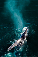
The "Colonel" kept us safe at all times, even while circling above breaching humpbacks, and he made sure we always had enough fuel in the tank to make it home before dark.
Doors Off over Baja California's Wild Coast
It was the large-format Sierra Club book, BAJA CALIFORNIA and the Geography of Hope by Joseph Wood Krutch and Eliot Porter, that first put Baja California on the map for me.
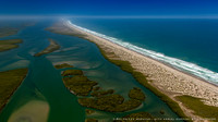
Flying over Magdalena Bay with a coastline extending as far as the eye can see, I recall a quote that still haunts me with the allure of unspoiled wilderness, “Baja California is a wonderful example of how much bad roads can do for a country.”
The aerial images tell a great story about Baja California.
When most people think of Baja they picture Cabo San Lucas, the playground for holiday makers and movie stars. But the real story is about what lies beyond the nightlife, golf, and sport fishing.
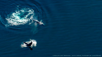
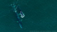
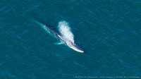
Baja is one of the best places in the world to see the great whales – blue, fin, humpback, sperm – dolphins by the hundreds, and also the elusive whale shark.
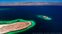
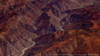
Like the Galapagos, Baja has many unique and endemic species, but is far more varied in it's geology and scenery, located along a rift zone related to the San Andreas fault system.
Like the Galapagos, much of Baja is protected as biosphere reserves, national parks, and marine reserves.
And like the Galapagos, all the islands in the Sea of Cortez and the coral reef at Cabo Pulmo, are designated a World Heritage Site by UNESCO.
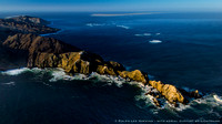
The story is also about an adventure – an aerial expedition by small plane shooting images and video with the doors off for an unobstructed view. We explored over 3,500 nautical miles from the air, or 3.5 times the length of the peninsula.
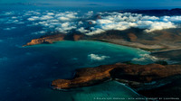
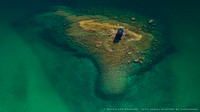
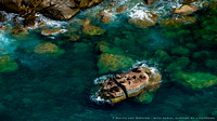
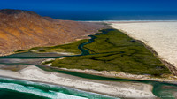
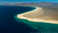
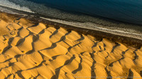
The Baja peninsula is spectacular from the air, with endless beaches, extensive wetlands, and remote islands set against a cobalt sea.
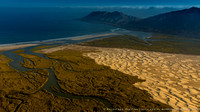
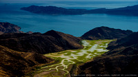
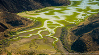
But what impressed me the most was Magdalena Bay, the largest wetland in all of Baja, and one of the world's first whale sanctuaries – protecting the California gray whales.
The aerial images of barrier islands, twisting tidal channels, and barchan dunes from Magdalena Bay show the world how special Baja California's wild coast really is.
And also like Galapagos, Baja is at risk from a growing population, reckless development, and over-exploitation of marine resources.
For real hope, Baja needs to become a world icon for wildlife and conservation, just like the Galapagos Islands.
A story in the magazine will help put Baja California and the Sea of Cortez on the map and, hopefully, will have a huge impact on it's future.
© Ralph Lee Hopkins
© Ralph Lee Hopkins